
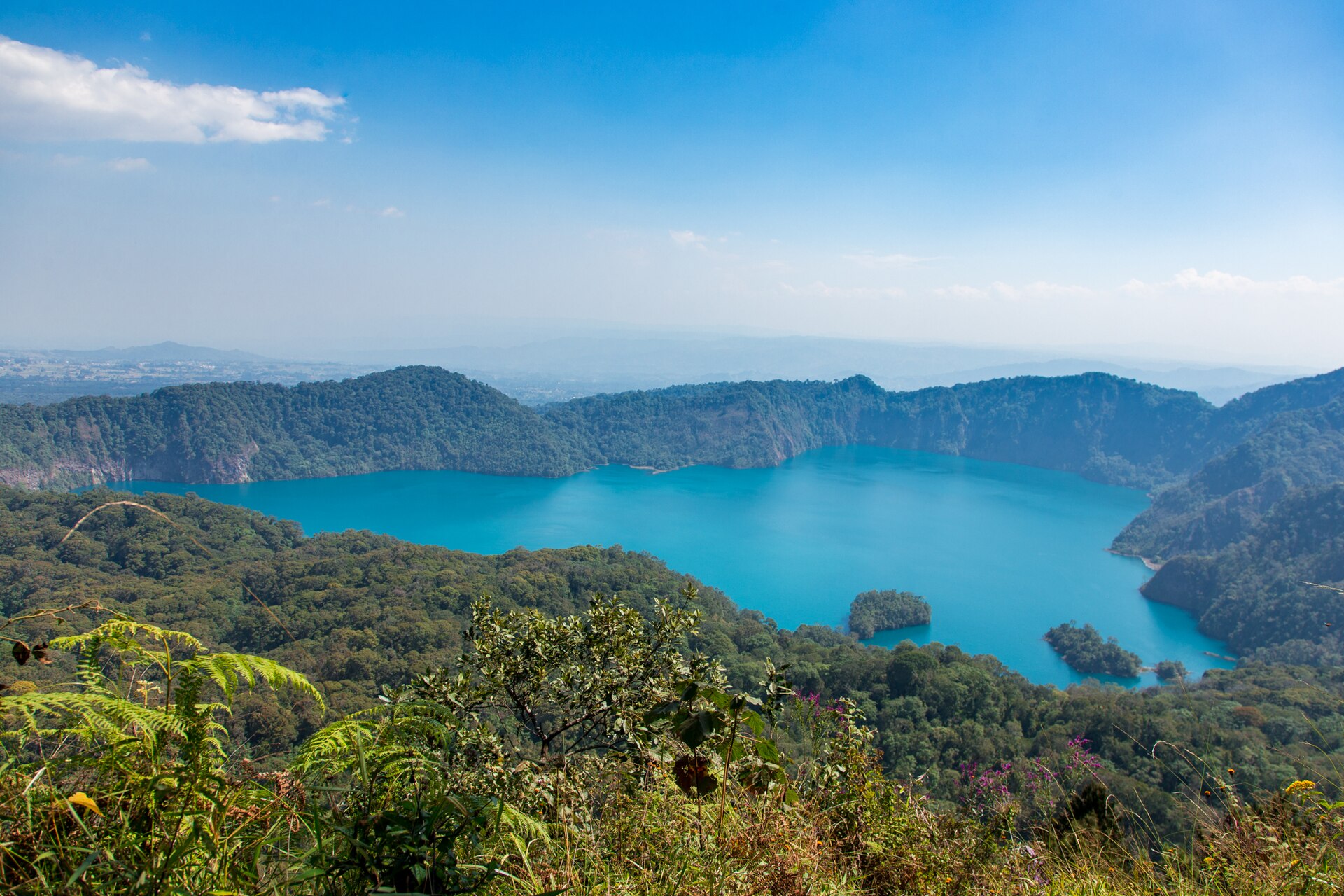
A crater lake in forest on Mount Rungwe
The Lake Ngozi Nature Forest Reserve covers the Rungwe massif and the caldera lake on its flank, between Mbeya and Tukuyu in the Southern Highlands. Tanzania Forest Services manages it and gives its area as 24,680 hectares, across Rungwe and Mbeya districts.
It is the most rewarding half-day walk in south-western Tanzania, and for most visitors to Mbeya the reason to stay an extra night.
The lake
TFS describes Lake Ngozi as the second largest crater lake in Africa, and notes that it is shaped like the African continent — a claim that sounds like a tour guide’s flourish until you see it from the rim, where it is obvious.
Ngozi is a caldera rather than a simple crater, with a summit elevation of 2,614 metres and a last recorded eruption around 1450. The walk climbs through forest from the road to a rim above deep green water, with forest running to the shoreline on every side. It is neither long nor technical, but it gains altitude steadily and the footing is muddy for much of the year.
Mount Rungwe
The same reserve holds Mount Rungwe, and the two headline figures for it disagree.
Tanzania Forest Services, the managing authority, gives Rungwe’s altitude as 2,981 metres and calls it the highest peak in the Southern Highlands. The Smithsonian Institution’s Global Volcanism Program, which catalogues the world’s volcanoes, records Rungwe as a stratovolcano of 2,953 metres with a last known eruption around 1250. Both are authoritative within their own domain — a land-management agency and a volcanological database — and this guide gives both rather than choosing between them or averaging.
Rungwe is one of only two places in Tanzania where the kipunji occurs. Found in the Udzungwa in 2003 and described in 2004, it was placed in a new genus, Rungwecebus, named for this mountain — the first new African monkey genus described in decades. TFS names it among the reserve’s attractions. It lives high in the forest canopy and is difficult to see even for researchers, so treat any sighting as luck.
What else is in the reserve
TFS lists, beyond Ngozi, Rungwe and the kipunji: the Lusiba crater lakes, ritual sites known as Masieto, black and white colobus monkeys, the bamboo belt, the Kiwira and Kibisi rivers, and views out across the rift valley.
The bamboo belt is worth knowing about: bamboo at altitude on a volcano is a distinct habitat, and it is the source of ulanzi, the bamboo wine tapped from young shoots across these highlands.
Activities
TFS lists bird watching, trekking, photography, camping, picnicking, nature viewing and meditation, and cultural and traditional activities.
In practice the reserve delivers three things: the walk up to the Ngozi rim, which is a straightforward day hike; the ascent of Rungwe, which is longer and harder and needs an early start; and forest walking on the lower slopes, which is where the colobus and the forest birds are.
As with other Tanzania Forest Services nature reserves, no published compulsory-guide rule could be found, unlike in the national parks. Guides are arranged locally, and on Rungwe in particular that is not optional in any practical sense.
One consequence of that Tanzania Forest Services management is financial. TFS reserves sit outside the TANAPA tariff booklet that fixes what a national park gate charges, and no current published TFS figure could be confirmed for this guide, so none is quoted here. Treat reserve entry and the local guide as two separate costs to settle before setting off, and see the guide to what conservation charges add to a Tanzanian trip for how the published tariffs are built and where they stop.
Getting there
TFS describes the approach: from Dar es Salaam, fly to Songwe International Airport, drive the Tanzania–Zambia highway to Mbeya — about 815 kilometres — or take the TAZARA train to Mbeya. From Mbeya the reserve is about 22 kilometres via Iduda or 33 kilometres via Mchangani.
The reserve has several sites suitable for camping. Other accommodation is in Tukuyu township or Mbeya city. The guide to reaching the Southern Highlands covers the flights, the TAZARA line and the highway that get you to Mbeya in the first place.
TFS names as nearby attractions Mbeya Peak, Kitulo National Park, the Malasusa and Kaporogwe waterfalls, God’s Bridge, Kijungu, the Kisiba crater lake, Matema Beach, the Mbozi meteorite and the Mpanga–Kipengere Game Reserve.
When to go
The south-western highlands are unimodal: one rainy season from November into April or May, wetter in its second half. Given that this is among the wettest country in Tanzania, June to October is the practical walking season. Cloud on the Rungwe summit is common in any month, and the Ngozi rim can be in mist even on a clear morning below. The seasonal guide to southern Tanzania sets that single wet season against the rest of the country.
Common questions
How big is Lake Ngozi?
Tanzania Forest Services describes it as the second largest crater lake in Africa and notes its resemblance in shape to the African continent. No surface-area figure is published by the managing authority, so none is given here.
How high is Mount Rungwe?
Tanzania Forest Services gives 2,981 metres and calls it the highest peak in the Southern Highlands. The Smithsonian Global Volcanism Program gives 2,953 metres. Both are carried here.
Is Rungwe an active volcano?
The Global Volcanism Program records Rungwe as a stratovolcano whose last known eruption was around 1250, and Ngozi as a caldera with a last recorded eruption around 1450. Neither has erupted in historical memory.
How far is it from Mbeya?
Tanzania Forest Services gives about 22 kilometres via Iduda and 33 kilometres via Mchangani.
How long does the Ngozi walk take?
No authority publishes a duration, so none is given. It is a forest climb rather than a stroll, gaining altitude steadily on ground that is muddy for much of the year. Treat it as a half day with a guide.