
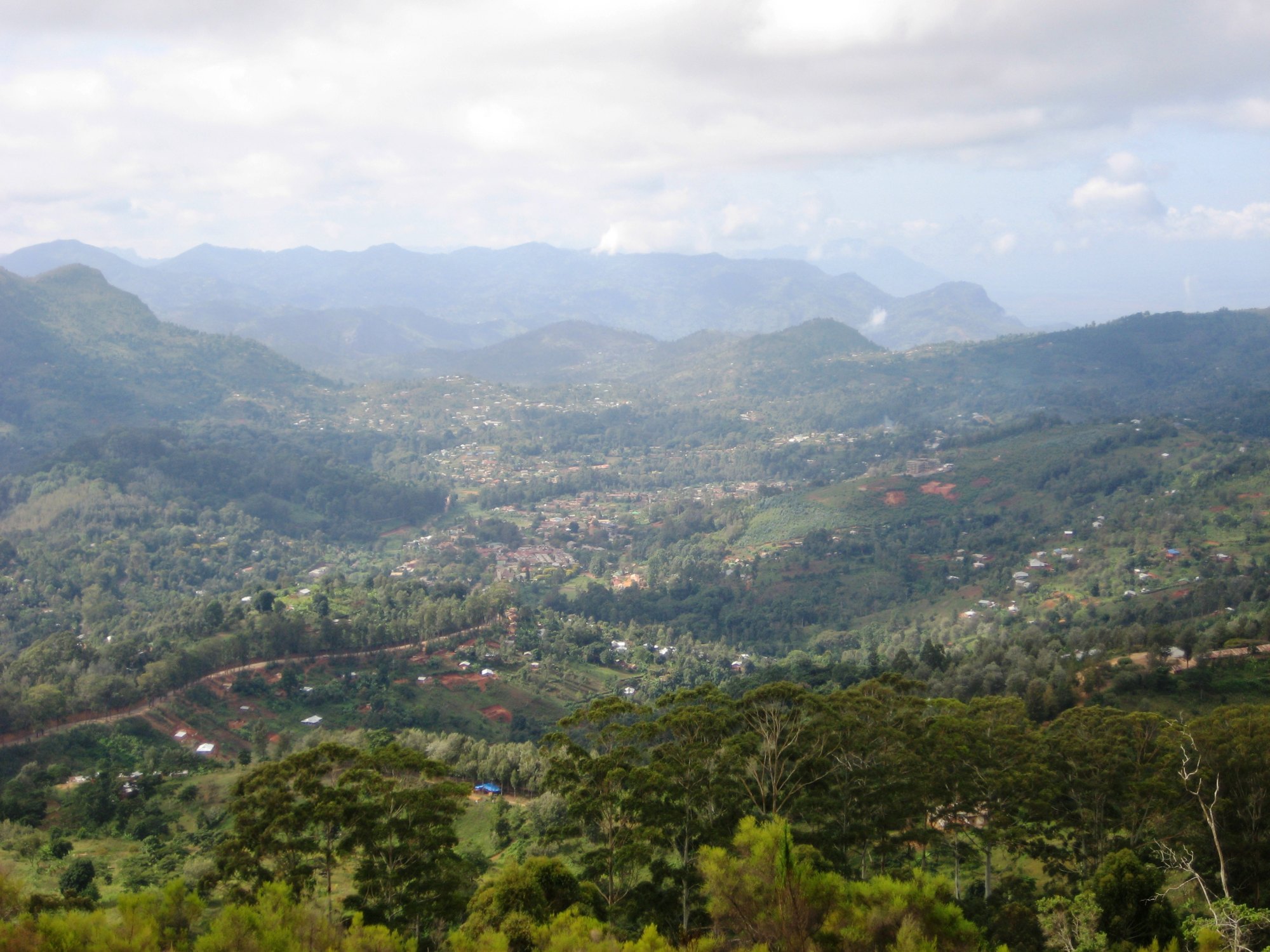
Why you sleep in Lushoto
Lushoto is the base for walking in the West Usambaras, and it does not really do anything else. There is no park gate here, no game to drive out and look at, and nothing on an itinerary that has to be ticked. What there is instead is a cool highland town in a bowl of terraced hillsides, with a footpath network running out of it in every direction and forest above it, and several days’ worth of walking that costs nothing and requires no permit.
It is also a change of register. People arrive in the Usambaras either at the end of a northern circuit safari or on the way between the parks and the coast, and the shift from the dust and the vehicle to a temperate, densely farmed, intensely green landscape is most of the appeal. Lushoto is where you sleep, eat and arrange guides while doing it. How many nights that break deserves inside a longer trip is worked through in the guide to how long a Tanzanian itinerary needs.
Where Lushoto sits
Lushoto District Council is in Tanga Region, in the north-east of the country. By its own account the district covers roughly 2,300 square kilometres, lies largely within the Usambara Mountains, and spans elevations from 300 to 2,100 metres. It splits into two very different halves: a mountain zone with relatively high rainfall, and the drier Umba Plains below, drained by the Umba River. The district borders Kenya to the north, Muheza District to the east, Korogwe and Bumbuli to the south, and Kilimanjaro Region to the north-west.
At the 2022 census the district held 350,958 people, which makes it one of the most populated rural councils in Tanga Region. That number matters to a walker: this is not wilderness. The Usambaras around Lushoto are farmed hard, right up the slopes, and the paths you walk on are the roads people use to get to market.
The population is predominantly Sambaa, and the district’s economy is smallholder farming — vegetables, fruit, maize, beans, potatoes and coffee — with forestry alongside it. Lushoto’s vegetables travel a long way; a great deal of what is sold in Dar es Salaam is grown on these hillsides.
A correction worth carrying
Soni, the small town on the climb up from the plains that a lot of travel copy still files under Lushoto, is not in Lushoto District. Bumbuli District Council was created out of Lushoto in 2013 because the district was too large to administer, and Soni is one of its wards, as is the ward called Usambara. Bumbuli borders Lushoto, Korogwe and Mkinga. Most published descriptions have not caught up, and it makes a practical difference if you are dealing with district offices rather than a guide.
Arriving and leaving
Lushoto is up a hill, and the drive up is part of the experience. Tanzania Forest Services gives the road distances to Lushoto as about 340 kilometres from Dar es Salaam and about 310 kilometres from Kilimanjaro. The usual approach leaves the Dar es Salaam–Arusha highway at Mombo, in Korogwe District, and climbs the escarpment through Soni — a series of hairpins that gains most of the altitude in a short distance.
That road position is the reason the Usambaras work so well as a break in a longer trip. Lushoto is roughly on the way between the northern circuit and the coast, rather than being a detour to nowhere. Coming down the other side puts you within reach of Tanga and the coast; going back the other way puts you on the road towards Same, Mkomazi and Moshi. The guide to driving between the northern circuit and the coast covers what those legs really cost in hours.
What you do from Lushoto
The viewpoints
Irente is the classic half day: a short walk out to a cliff edge where the plateau stops and drops more than a kilometre to the Maasai plain below. Mambo, further north, is the other named viewpoint, worth the longer drive and looking north towards Kenya. Tanzania Forest Services names both among the attractions near its Magamba reserve.
Magamba forest
Magamba Nature Forest Reserve begins nine kilometres from Lushoto town and is the managed forest block above it, with named trails including the route to Kwahondo Peak at 2,287 metres, the highest point in the Usambaras. There is also a hillside tunnel dug by German residents during the First World War, which local marketing tends to describe as a cave. It has its own page.
Village-to-village walking
The distinctive Usambara trip is not a peak but a traverse: two to five days of moderate walking from village to village, sleeping in villages and simple guesthouses rather than under canvas, at an altitude of roughly 1,500 to 2,000 metres. It is the gentlest multi-day walking in Tanzania and for a lot of people the most enjoyable. The mountain trekking guide covers the routes and the practicalities, including the honest note that no authority publishes itinerary lengths for them, so the day counts in circulation are operators’ rather than official.
Shorter outings are covered in the day hiking guide, the forest walk guide and the waterfall hiking guide. The falls around Soni and Kisasa are the usual objectives. The Soni falls are in Soni town itself, on the Mkuzu river, and are not part of the Magamba reserve, so the reserve’s rules and arrangements do not apply there.
One practical point on which every source agrees: take a guide. The path network is dense, unmarked and genuinely confusing, and you are walking on village land rather than through a reserve, so a guide is a courtesy as much as a navigation aid.
Farms, tea and villages
The farming is the landscape here, and seeing it properly is a legitimate day out rather than a filler. See the farm tours guide, the village tours guide and, for the estates lower down the range, the tea plantation tours guide. Cycling on the ridge roads is covered in the mountain biking guide.
Birds
The Usambaras are an Eastern Arc block with exceptional endemism, and serious birders generally head for Amani in the East Usambaras rather than Lushoto. There is still good forest birding at Magamba; see the bird watching guide.
When to come
Lushoto is in the bimodal zone — Vuli from October to December, Masika from March to May, on the Tanzania Meteorological Authority’s definitions. The mountain zone gets substantially more rain than the Umba Plains below it, and the paths become slippery clay rather than impassable.
The more useful warning is temperature. At 1,400 metres and upwards, in cloud a lot of the time, Lushoto is cold by Tanzanian standards, especially at night and especially in June and July. Visitors arriving from the coast with beach clothing are consistently caught out. The Usambaras make their own weather, and a forecast for Tanga is not a forecast for Lushoto. The national seasonal guide sets the bimodal calendar against the single wet season most of the country runs on.
Common questions about Lushoto
What is there to do in Lushoto?
Walking, mainly: the Irente and Mambo viewpoints, the trails in Magamba forest above the town, waterfalls, and multi-day village-to-village traverses. Farm and village visits, cycling on the ridge roads, and forest birding fill the rest.
How do you get to Lushoto?
By road up the escarpment, leaving the Dar es Salaam–Arusha highway at Mombo and climbing through Soni. Tanzania Forest Services gives about 340 kilometres from Dar es Salaam and about 310 kilometres from Kilimanjaro.
Is Soni in Lushoto District?
No. Soni is a ward of Bumbuli District Council, which was created out of Lushoto District in 2013. A lot of travel writing still places it in Lushoto.
How cold does it get?
Cold enough to want a fleece and long trousers, particularly in the evenings and in the middle of the year. The district spans 300 to 2,100 metres and Lushoto sits well up that range; cloud and drizzle are common even outside the rains.
Do you need a guide to walk in the Usambaras?
Not legally, for the most part — most walking is on public village paths rather than inside a reserve. Practically, yes. The path network is unmarked and complicated, and a local guide is also the normal courtesy when walking through people’s farmland.
Is Lushoto good for wildlife?
Not for large mammals. The Usambaras are a densely farmed landscape with forest remnants, and their significance is botanical and ornithological rather than big-game. Birders usually prefer Amani in the East Usambaras.
How many days does an Usambara walk take?
Anything from a half day to about five. No authority publishes standard route lengths, so the day counts you will see attached to named routes are operators’ framings rather than official ones.