
Rock City
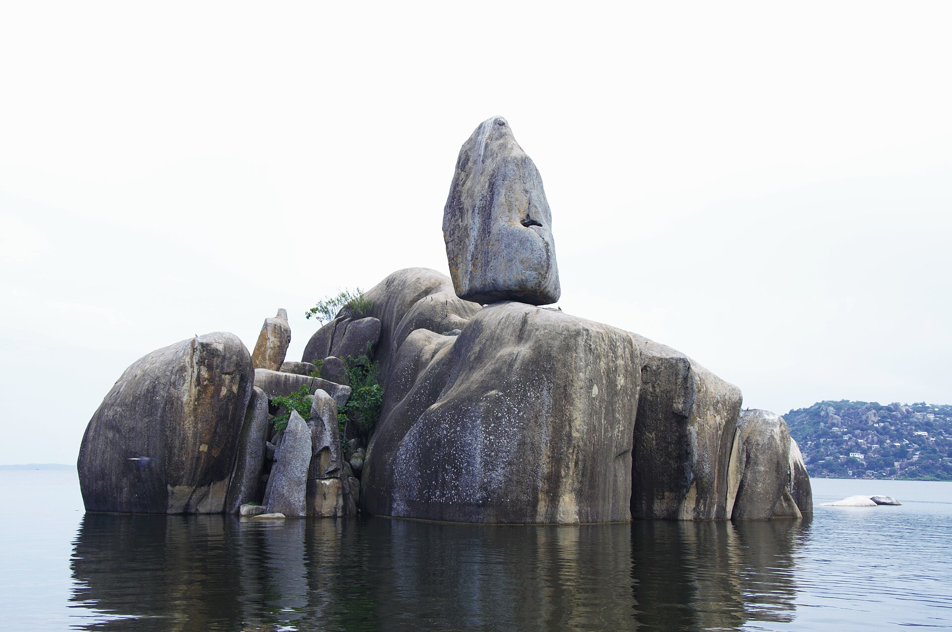
Mwanza is Tanzania’s second city and its lake port, built on and among enormous granite boulders on the southern shore of Lake Victoria. Mwanza City Council’s own name for it is Rock City, and the rocks are not a metaphor — they sit in the streets, in the water, and on the hills above the harbour.
The city was established in 1892 as an administrative centre and a commercial hub, built largely to control production from the cotton-growing country around the lake. It became a municipality in 1978 and was upgraded to city status in 2000. Its total area is 256.45 square kilometres, of which 184.90 square kilometres — about two-thirds — is dry land.
Before any of that, the area was governed by the chiefdoms of the Sukuma, Zinza, Luo, Kara and Kerewe. Under British administration after the First World War, Mwanza sat within Lake Province, which grouped the districts of Mwanza, Biharamulo, Bukoba, Maswa, Shinyanga, Musoma and Kwimba before being divided.
What there is to see
Bismarck Rock
The city’s emblem: a large boulder balanced improbably on others in the water of Lake Victoria, near the Kamanga ferry. Mwanza City Council describes it as the ultimate icon of the city and notes the small public park beside it. It is a sunset spot and a photograph rather than an attraction that takes an afternoon, and it is genuinely good at being that.
Saanane Island National Park
Saanane is the smallest national park in Tanzania and it is inside the city. The city council gives the crossing as a ten to fifteen minute boat ride from the TANAPA offices at Capri Point. Zebra, impala, rock hyrax, vervet monkeys and crocodiles, on 2.18 square kilometres of granite and scrub, with walking trails and bird watching. Treat it as a half-day.
The German-era town
Mwanza City Council names Gunzert House, an old German-period building in the city centre, and the Hanging Tree, a site used by the German colonial administration for executions. The historical walking tours guide covers this kind of walking in Tanzanian towns.
Mwaloni Market
The fish market, and the best single place to see what the lake actually does for a living. The food and market tours guide is the relevant reading.
The islands
Mwanza City Council names Saanane, Ukerewe and Nazareth among the islands reachable from the city, and describes lake and island excursions as the most significant untapped area for tourism growth here. Ukerewe is the largest island in Lake Victoria and a substantial destination in its own right rather than a boat trip. See the boat safari and kayaking guides.
Mwanza as a base
Mwanza is the practical entry point for the western side of the safari map, and that is much of its value to a traveller.
It is the road and air gateway to the western corridor of the Serengeti, which is a very different proposition from arriving through Arusha. It is the embarkation region for Rubondo Island National Park, for which TANAPA names Mwanza airport as an approach, with onward road transfer to a lakeside landing point, or a private boat taxi. And it is the northern terminus of the Central Line’s Mwanza branch, which runs from Tabora via Isaka and Shinyanga — see rail and ferry journeys. Tanzania Railways Corporation lists Isaka–Mwanza among its standard gauge railway projects.
Ferries connect Mwanza with the other lake ports, including Bukoba on the western shore and Musoma to the north-east. Between the airport, the lake ferries and the Central Line railhead, Mwanza is one of the best-connected cities in the country — see the guide to Tanzania’s internal transport.
Rock art around Mwanza
The granite that gives the city its nickname also carries rock art. In February 2024 Tanzania, Kenya and Uganda jointly submitted “Geometric rock art in Lake Victoria Region” to UNESCO’s tentative list as a transnational serial nomination, under reference 6739 and cultural criteria (iii) and (vi). The Tanzanian component comprises 46 sites, of which two are at Mwanza; the rest cluster at Bukoba, in Bukoba District, at Muleba and at Musoma.
The images are large red geometric finger-paintings on granite outcrops. Dating carried out at two comparable Ugandan sites puts paintings in this tradition between roughly 1,000 and 5,000 years old. The submission notes that Kondoa remains the only inscribed rock-art landscape in East Africa, and that the geometric tradition around Lake Victoria has attracted far less research attention than the fine-line traditions of southern Africa.
This is a nomination on a tentative list, not an inscribed World Heritage site, and the sites do not come with visitor infrastructure. Treat it as a reason to ask locally rather than as a ready-made excursion. See the archaeological tours guide.
Bilharzia
The best-documented bilharzia outbreak in the travel medicine literature anywhere on Lake Victoria involved Mwanza. A 2011 report in the Journal of Travel Medicine by Chunge and colleagues described 77 people from Nairobi who attended a church retreat at Mwanza in 2008; 66 of them were diagnosed with acute Schistosoma mansoni infection. The paper’s own conclusion is that the outbreak highlights the risk of swimming in Lake Victoria.
Boat trips, ferries, fishing and walking the shoreline carry no equivalent risk — it is contact with the water that matters. The United States Centers for Disease Control and Prevention names only the sea and adequately chlorinated pools as safe for swimming in countries where schistosomiasis occurs, and does not rank lakes or publish a safe distance from shore. The fuller discussion is in the Lake Victoria guide.
Seasons
Mwanza is in the Tanzania Meteorological Authority’s Lake Victoria zone, which TMA defines as the Kagera, Geita, Mwanza, Shinyanga, Simiyu and Mara regions together with the Kakonko and Kibondo districts of northern Kigoma. These are bimodal: two rainy seasons a year, Vuli from October to December and Masika from March to May.
The October start is the part most often reported wrongly. TMA’s own Vuli forecasts are explicit that the season is October to December for this zone and that the rains typically begin in the last week of September or the first week of October around the lake. The national seasonal guide sets the lake zone against the rest of the country.
Common questions about Mwanza
Why is Mwanza called Rock City?
Because of the granite boulders and outcrops that define the landscape in and around the city. Mwanza City Council uses the name itself.
What is Bismarck Rock?
A large boulder balanced on other rocks in the water of Lake Victoria near the Kamanga ferry, with a small public park beside it. It is the city’s best-known landmark and a sunset viewpoint.
Can you visit a national park from the city centre?
Yes. Saanane Island National Park is a ten to fifteen minute boat ride from the TANAPA offices at Capri Point. It is Tanzania’s smallest national park at 2.18 square kilometres.
Is Mwanza a good gateway to the Serengeti?
It is the natural approach to the western corridor, by road or air, and a genuinely different entry to the park from the northern circuit route through Arusha.
Is it safe to swim in the lake at Mwanza?
Bilharzia is documented here specifically. A 2011 Journal of Travel Medicine report found 66 of 77 visitors infected after a retreat at Mwanza. Boating and fishing are a different matter; it is water contact that carries the risk.
When does it rain in Mwanza?
Two seasons. Vuli from October to December and Masika from March to May, per the Tanzania Meteorological Authority, which places Mwanza in its bimodal Lake Victoria zone.
How do you get to Mwanza?
By air to Mwanza airport, by rail on the Central Line branch from Tabora through Isaka and Shinyanga, by road, or by lake ferry from the other ports.