A working port city, not a resort
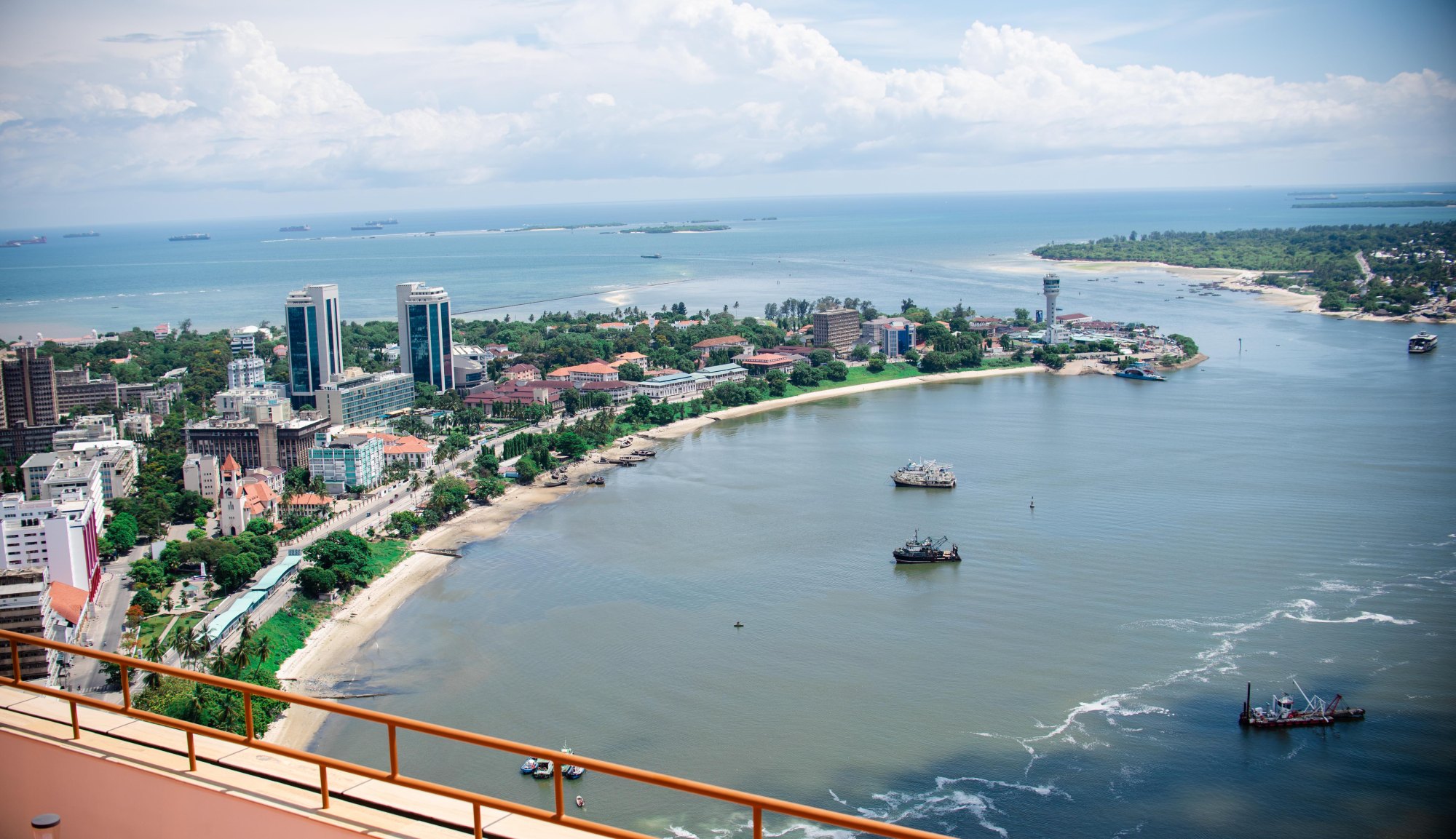
Dar es Salaam is Tanzania’s largest city, its main port and the point through which most visitors to the southern circuit and the islands actually pass. It is not the capital — Dodoma is — and it does not sell itself as a destination in the way the northern safari towns do. What it is, is a harbour city on the Zanzibar Channel with a Swahili, Omani, German, Indian and British past layered into a few walkable blocks, an excellent national museum, a fish market that runs on its own timetable, and four uninhabited island reserves within sight of the beach hotels.
The name is Arabic and is usually rendered in English as “haven of peace”, which describes the harbour rather than the traffic. The Dar es Salaam City Council in its present form dates only from 24 February 2021, when city status was conferred on the former Ilala Municipal Council; the wider conurbation is governed through several councils, and the built-up area long ago outran any of their boundaries. For a traveller this matters less than the practical geography: a compact colonial-era centre on the harbour, a long northern beach strip, and a ferry terminal that connects to Zanzibar and beyond.
Most itineraries treat Dar as a transit night. It rewards a full day more than that reputation suggests, and a day here is a genuinely useful orientation to everything the coast further north and south is going to show you. Where that day comes from in a fixed number of nights is the question the guide to how long a Tanzanian trip needs works through.
The old centre
The historic core sits along the harbour front and the streets immediately behind it. This is where the city’s institutional buildings ended up — the Askari Monument at the junction that still organises the downtown grid, St Joseph’s Cathedral and the Azania Front Lutheran Church on the waterfront, the Botanical Gardens, and the National Museum and House of Culture at Posta. It is compact enough to walk, and walking it with a guide who can read the buildings is the difference between a row of old facades and a legible sequence of German, British and Indian Ocean commercial architecture. The general approach, and what to ask of a guide, is set out in the guide to historical walking tours.
The National Museum and House of Culture is the flagship of the National Museum of Tanzania and stands opposite the Institute of Finance Management at Posta. Its companion site, the Village Museum, is out at Kijitonyama, near the junction of Ali Hassan Mwinyi Road and Mwenda Street, and is an open-air collection of traditional dwelling types from around the country rather than a gallery. Between them they are the best single-day introduction to Tanzanian material culture available anywhere in the country. The guide to museum tours covers what the national collections hold and how they are organised.
Kariakoo is the other kind of downtown — a dense wholesale and retail market district covering many blocks, loud, crowded and not a tourist attraction in any curated sense. Kivukoni fish market, on the harbour near the ferry terminal, is where the night’s catch is auctioned in the morning; it is at its most interesting early and it is a working market, not a display. Both are best approached through a food and market tour, which is also the easiest way to eat well here.
The islands off the beach
North of the harbour, inside the city’s own boundary, lie four small island reserves — Bongoyo, Mbudya, Pangavini and Fungu Yasin — gazetted separately in June 1975 and now managed together as the Dar es Salaam Marine Reserves by the Marine Parks and Reserves Unit. Their general management plan puts the combined protected area at 3,044.4 hectares, of which only about 137 hectares is dry land, and records all four as uninhabited.
They are not equivalent. Bongoyo is the one most people visit, a mix of small sandy coves and coral-rag rock flats. Mbudya is the largest of the four and is covered in tropical coastal forest, with reef on its sheltered western side and seagrass across the lower intertidal. Pangavini is a coral-rag island ringed by steep cliffs that make it effectively inaccessible; the plan describes it as a sanctuary for birds and snakes rather than a place to land. Fungu Yasin is not really an island at all but a sandbank that appears at low tide over extensive seagrass beds.
Day trips run out by boat from the northern beaches, and the water is the point: swimming, snorkelling over the reef flats, and sandbank and island hopping when the tide is right. The management plan is candid that the reserves have suffered from unregulated use — visitors congregating on a handful of small beaches, poaching, and pollution carried in from the mainland — and that enforcement of the no-take zones only began in earnest thirty years after gazettement. Turtles nest, dolphins and whales are recorded in these waters, and the plan notes seahorses on the seagrass beds. None of that is a guarantee of a sighting on any given morning.
Coco Beach at Oyster Bay is the city’s own stretch of public shoreline and is a social space more than a swimming one — busiest at weekends and in the late afternoon.
Getting in, out and onward
Dar is the hinge of the southern half of the country. Ferries to Zanzibar leave from the harbour terminal in the city centre and the crossing is the standard way to reach Stone Town and Zanzibar without flying. The city is also the road head for the drive south to Kilwa Masoko, the approach to Nyerere National Park, and the nearest large airport to Saadani National Park and Bagamoyo, which sits about 65 kilometres up the coast.
Rail matters here in a way it does not elsewhere in East Africa: Dar is the eastern terminus of the line to the interior and of the TAZARA line toward Zambia, and both are journeys in their own right rather than simply transport. The guide to rail and ferry journeys covers what these trips actually involve. The guide to arriving in Tanzania and moving between its regions sets the railways alongside the flights, the road hub and the two ways of crossing to Zanzibar.
Inland and south-west of the city, in the hills behind the airport, is Pugu-Kazimzumbwi Nature Forest Reserve — coastal forest, bat caves and short trails, reachable on tarmac in well under an hour, and the obvious half-day escape for anyone with an evening flight.
When to come
The Tanzania Meteorological Authority places Dar es Salaam in the northern coastal zone, which has two rainy seasons a year rather than one. Vuli, the shorter of the two, runs from October to December; Masika, the longer and heavier, from March to May. This is the official framing and it is worth using, because the tourism shorthand of “short rains in November” consistently starts the season a month late.
Between and around those, the city is hot and humid year-round. June to September is the coolest and driest stretch and the most comfortable for walking the old centre; January and February are hot and largely dry. Rain on this coast tends to arrive hard and clear, rather than settling in for days, but the March-to-May period can genuinely disrupt a beach or boat day. The national rainfall calendar sets the coast’s two seasons against the single season most of the interior runs on.
What the city is good for
- A first orientation to the Swahili coast. The national collections, the old harbour front and a market morning give you the frame that Bagamoyo, Kilwa Masoko and Stone Town then fill in. Background on the coast as a whole is in the guide to Swahili cultural tours.
- A day on the water without leaving the city. The island reserves are close, cheap to reach and genuinely quiet on a weekday.
- Food. Dar’s Indian Ocean and South Asian cooking is the best on the mainland, and cooking classes and market tours both run here.
- A staging point. Almost every southern and coastal itinerary in this country either starts or ends here.
What it is not good for is a beach holiday on its own account. The northern hotel strip is pleasant and convenient, but the water and the sand improve enormously a few hours in either direction — Pangani and Saadani to the north, Kilwa and the southern islands below.
Common questions
Is Dar es Salaam the capital of Tanzania?
No. Dodoma is the capital and holds the Parliament and the relocated government ministries. Dar es Salaam remains the largest city, the main port and the commercial centre, and its own City Council describes it as the country’s leading commercial city and a hub for trade, port and logistics services.
How long do you need here?
One full day covers the museums, the old centre and a market. Two lets you add an island day. Beyond that the returns fall off quickly unless you have business here or are waiting on a connection.
Which island should you go to?
Bongoyo is the most visited and the easiest to reach. Mbudya is often called the largest, and it is by reserve area, but most of that area is water: the reserves’ own management plan gives Bongoyo more dry land than Mbudya. Mbudya is the more forested of the two. Pangavini is ringed by cliffs and is described in the reserves’ management plan as inaccessible, and Fungu Yasin is a tidal sandbank rather than an island you can spend a day on. Boats run from the northern beaches, and the reserves charge their own entry.
Can you reach Zanzibar by boat from the city?
Yes. Passenger ferries run from the terminal in the city centre to Zanzibar, and it is the usual alternative to the short flight. The guide to rail and ferry journeys covers the crossings and the rail routes inland.
Is the old centre safe to walk?
The downtown core is walked daily by residents and visitors alike, and a guided walk is the normal way to see it. Ordinary city precautions apply, more so after dark and around the markets and the ferry terminal, where crowding is the main risk to belongings.